The Streetcar Project Initiates the Reconstruction of Essential Bridge Structures

The streetcar guideway – the track – is the essential part of the project. It is how the vehicles travel throughout the corridor, which gives passengers a reliable mobility option and provides property owners and developers with the promise of continued high-quality transit service through the permanency of the rails. Therefore, what the tracks rest on is equally, if not more, important; it is the base that supports the track guideway. This is the primary reason the project is going to such great lengths to replace, move and improve the underground utilities.
However, not all of the streetcar route rests directly on the ground, there are three bridges traversed by the corridor: 10th Street over the Gene Leahy Mall (between Douglas and Farnam) as well as Farnam and Harney streets over Interstate 480.
The new Harney Street bridge opened on November 26. The Farnam Street bridge will be rebuilt next. Why do these bridges need to be replaced? It is a bit complicated and involves diving into some urban Omaha history.
The 1950s Interstate Development
To get an understanding of why the Harney and Farnam bridges over I-480 needed to be replaced, let us take a time-travel trip back to the 1950s. Try to put yourself back in this era: the world war had recently ended, and infrastructure projects (like new roadways) were taking the country by storm to propel new development for growing families. Development patterns were trending toward serving people in automobiles in suburban areas, which coincided with the ending of streetcar service in Omaha in 1955.
Like many cities across the country, Omaha was to be on the “Dwight D. Eisenhower National System of Interstate and Defense Highways,” commonly referred to as the Interstate Highway System, formed by the Federal-Aid Highway Act of 1956. Omaha lucked out in terms of interstate highway access and would be directly located on the east-west I-80 corridor and adjacent to the north-south I-29 route.
Omaha was also included in two auxiliary interstate highways, I-480 planned through the center city, and I-680 planned north and west of the growing suburbs. In 1957, before being given a federal designation, these were planned as “Route 3” (I-480) and “Route 5” (I-680).
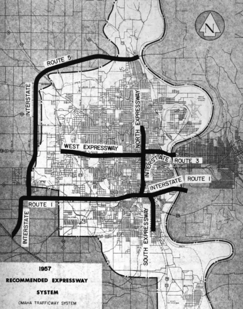
The 1957 Omaha Highway Plan Included the Never-Built West Expressway
Planning for I-480 was highly controversial, according to the book The Changing Image of the City: Planning for Downtown Omaha, 1945-1973 by Janet R. Daly-Bednarek. West of downtown Omaha, the interstate would break up existing neighborhoods. Bridges were constructed at Dodge, Douglas, Farnam, Harney, St. Mary’s Avenue and Leavenworth to provide access to and from the interstate, primarily to help motorists get in and out of downtown quickly.
Before the interstate construction, streetcar routes did not need to be concerned with interstate highway crossings and were more easily able to get into downtown, aside from the railroad crossings to the south.
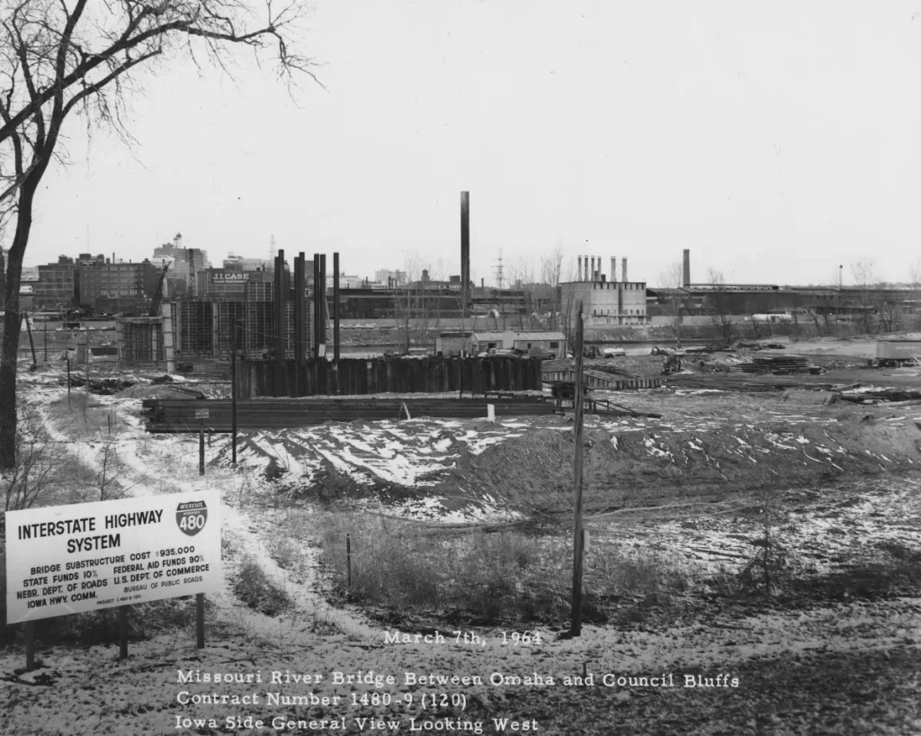
Photo of the I-480 Construction over the Missouri River from 1964
Construction of these bridges over I-480 began in 1962 and wrapped up by 1965. The interstate highways were funded without local dollars – 90 percent by the federal government and 10 percent by the state government. The bridges were largely unchanged for many decades, even though the city was changing around them – a greater focus on downtown as the heart of the city hastened in the 1990s with an attention on alternate modes of transportation besides the automobile, such as transit and active transportation uses, including walking and bicycling. The streetcar project is the epitome of this paradigm shift in thinking of urban development, as it connects to this increase in downtown development with the changing mobility trends.
The Omaha Urban Core Initiative
The Greater Omaha Chamber of Commerce organized these new ideas on downtown and midtown development into the Urban Core Strategic Plan, completed in March 2022. The plan combined land use and transportation initiatives into a dramatic and generation-defining package – a vision for city leaders and developers to follow in the future.
In addition to the construction of the initial streetcar line, the plan called for the Farnam and Harney bridges to be flanked by a “lid” built over I-480 to reconnect the neighborhoods and provide a better use of space above the interstate. Dodge and Douglas Street bridges would also be rebuilt, retaining the one-way design through downtown, although smoothing out the “S” curve from Dodge to Douglas. This is still conceptual, but gives an idea of what is possible in terms of transforming the area adjacent to the interstate.
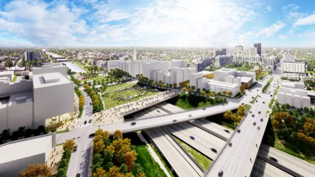
Graphic Showing the Ultimate Plan for new I-480 Bridges
In this sense, the streetcar is just the beginning of reinvestment in the infrastructure and improving the land use by promoting other transportation uses and making it safer for people to walk around to visit the businesses in the area, while underscoring the reconnection between downtown and midtown.
Besides needing to be replaced for the streetcar and Urban Core Strategic Plan, Harney and Farnam streets bridges were reaching the end of their useful life and would need to be replaced within 10 years to be considered safe for transportation. This is similar to the lifespan of many bridges that were initially built for interstate highway construction, and the other bridges built at this time will also need to be replaced soon.
What’s Next
With Harney Street completed, the Farnam Street bridge will be rebuilt next. This is anticipated to happen the week of January 5. Like Harney Street, the bridge will be closed for about a year while the new structure is built. The new Farnam Street bridge will include a bi-directional bike lane, as part of the Market to Midtown Bikeway 2.0 project.
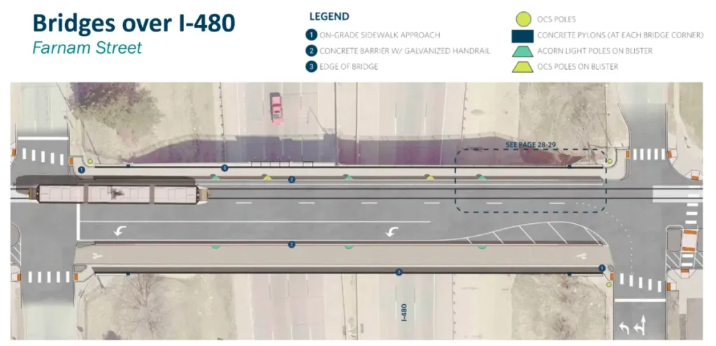
Graphic of Farnam Street with Bike Lane on the South Side
After the Harney and Farnam bridges are complete, the 10th Street bridge between Farnam and Harney, where the streetcar turns north from Harney Street to head up to Capitol Avenue, will need to be reinforced for streetcar track. This surface work on the bridge is anticipated to be complete in 2026 and will not require a complete closure of the bridge. The 10th Street bridge was built in the early 1980s as part of the original Gene Leahy Mall construction, and will last longer than the Farnam and Harney Street bridges.
The next time you drive or walk across the new Harney Street bridge, or take a streetcar across it in 2028, think about how this area is being reshaped in a way that it hasn’t been in almost 60 years. And try to envision how this part of town will continue to develop as a vital piece of reconnecting Omaha’s neighborhoods.
Eric Miller is the Streetcar Operations Manager for the City of Omaha. Erik has a 21-year career in the transit industry that includes work in both the private and public sectors and work on planning and implementing bus and rail projects for transit agencies all across the country.